The parish in its
current form dates from 1981, but its history goes back a lot further!
Beginnings
As the parish has
always been sparsely populated there is little documented history before the
Norman Conquest. The names of Wildboarclough (valley of the wild stream)
and Macclesfield Forest indicate earlier settlement and a Saxon cross (now
lost) stood at Standing Stone in Macclesfield Forest.
At the time of the
Norman Conquest the manor of Macclesfield, which probably included the land
of the current parish, was held by the last Earl of Mercia. Following
William Ippression of resistance to his Norman invasion during the
winter of 1069/70 the land around Macclesfield passed to the Norman Earls of
Chester, who ruled over Cheshire until 1237 when the earldom was resumed by
the Crown.
The district formed
part of the Macclesfield Hundred, but there is no mention of any hill
settlements in the Domesday Book. This is not surprising as the area was
not substantially settled until late Tudor times. At the time of Domesday
Book it formed part of the Forest of Macclesfield, an area of jurisdiction
designed to protest deer and other game. The Chamber in the Forest, in what
is now Macclesfield Forest, was probably a royal hunting lodge.
Farmsteads and the Stanley family
In 1403, Henry V
granted the Stanley family (created Earls of Derby in 1485) lands and
offices covering the parish. This began the Stanley family connection with
the area which continues to the present day, although their local estates
were confiscated under the Commonwealth and only returned some years after
the Restoration.
By the end of the 16th
century the parish was still sparsely populated with a small number of
farmsteads (e.g. Midgley, Clough House and Holt). It was not until the end
of the 17th century that Wildboarclough was recognised as a
township. By this time, more farmsteads existed and the population of the
parish had risen to around 300, but only around 20% of the land area was
enclosed.
By the end of the 18th
century more of the land was enclosed, but this was largely due to the
extension of the existing farmsteads rather than the creation of new ones.
While other
activities have left their mark, farming was and remains the dominant
activity shaping the landscape. The hill pasture of the parish continues to
produce lamb, wool and dairy products, while the upland heather moorland is
managed for grouse.
Industrialisation
Although the parish
today is largely rural and sparsely populated, it was substantially affected
by the Industrial Revolution and signs of the parish੮dustrial past are
visible to the eagle-eyed today.
Textiles
Like many other
upland valleys in the area around Macclesfield, the Clough and Dane valleys
were exploited to power textile mills.
Crag Mill in
Wildboarclough was built in 1793 and operated intermittently for the
spinning and printing of calico and other cloths. Designs were printed at
the mill on plain carpets provided by John Bright, one of which was
exhibited at the Great Exhibition of 1850.
 Crag
Hall was built in 1796 by the mill owner, while Crag Lodge housed the mill
manager and Edinboro Cottages housed mill workers. 3 mills were eventually
built on the site, but they were mostly demolished by 1957. Mill House and
the Old Post Office (right) are the only parts of the mill buildings that
substantially remain.
Crag
Hall was built in 1796 by the mill owner, while Crag Lodge housed the mill
manager and Edinboro Cottages housed mill workers. 3 mills were eventually
built on the site, but they were mostly demolished by 1957. Mill House and
the Old Post Office (right) are the only parts of the mill buildings that
substantially remain.
Workers from
Wildboarclough were employed on the other side of the River Dane at Gradbach
Mill, which was built in 1792 to spin linen yarn and remains substantially
intact in its current incarnation as a Youth Hostel.
Coal
Although not a
traditional mining area, a thin seam of low-grade coal in parts of the
parish was exploited over many centuries. The earliest reference to coal
bell-pits is from 1632 and there is still evidence of these pits today in a
number of places. Small-scale mining continued until the late 1920s with
the most significant workings at sites such as Dane Bower, Dane Thorn,
Cumberland Brook (Mouse Trap Mine), Greenhills and Robinsclough.
Quarrying
Sandstone
predominantly for building was quarried from the mid 18th
century, with the largest quarries at Dane Bower and Stoneway. Numerous
smaller quarries provided the stone for local farmsteads.
Water
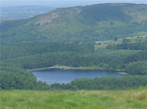 Two
of the significant landmarks in the parish are the reservoirs of Trentabank
and Lamaload. Trentabank Reservoir in the upper reaches of the River Bollin
was built in the 1920s and the 400 hectares of Macclesfield Forest, which
now surrounds the reservoir, was planted largely between 1930 and 1950.
This forest is an echo of the former royal hunting forest. Lamaload
reservoir on the River Dean also serves Macclesfield and was built between
1958 and 1964. At 308 metres above sea level it is the highest constructed
dam in England and was the first concrete reservoir in the country.
Two
of the significant landmarks in the parish are the reservoirs of Trentabank
and Lamaload. Trentabank Reservoir in the upper reaches of the River Bollin
was built in the 1920s and the 400 hectares of Macclesfield Forest, which
now surrounds the reservoir, was planted largely between 1930 and 1950.
This forest is an echo of the former royal hunting forest. Lamaload
reservoir on the River Dean also serves Macclesfield and was built between
1958 and 1964. At 308 metres above sea level it is the highest constructed
dam in England and was the first concrete reservoir in the country.
Church and State
While the civil
parishes of Macclesfield Forest and Wildboarclough were unified in 1981,
they have remained parts of separate church parishes since 1966.
Macclesfield Forest
now forms part of Rainow parish, but still proudly retains its own local
chapel. Forest Chapel (Church of St Stephen) in Macclesfield Forest was
built in 1673, although the current building dates from 1834. The chapel is
one of the few which maintains the tradition of an annual Rushbearing
Ceremony which is held on the first Sunday after 12th August.
In Wildboarclough,
the church of St Saviours is at the centre of one of the parishes in a
benefice which also includes Wincle, Bosley and North Rode. The church was
built in 1901 by the Earls of Derby.
There is also a
Methodist chapel on the boundary of the parish at Gradbach (built in 1849).
Although the parish
no longer supports its own school, schools existed at both Wildboarclough
(closed in 1972) and Macclesfield Forest (closed in 1961). The distinctive
buildings of both schools still survive today.
Floods
As the name
Wildboarclough (valley of the wild stream) suggests, there is a history of
dramatic summer flash floods which have affected both the River Dane and
Clough Brook.
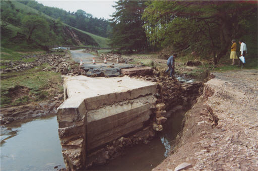
The earliest recorded
flood (Clough Brook) took place in 1816 when 4 bridges were swept away along
with more than 2 miles of road. Other floods were recorded of the River
Dane in 1828 and 1832 and of Clough Brook in 1872 (when a portion of the
mill was carried away), 1910 and 1930.
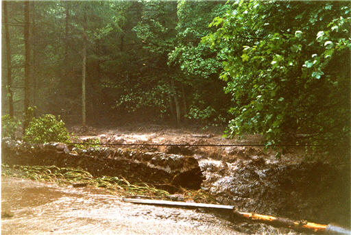
The most recent flood
took place on 24 May 1989 when a tidal wave swept down Clough Brook
destroying several bridges and sections of road. The road along the
valley did not re-open to through traffic for more than 6 months while
repairs were carried out.
For other pictures of the 1989 flood please follow the
following link.
Source: Valley of the Wild Stream, A History of
Wildboarclough by Antony Borrow (2004)
